Winds and seas will ease through this afternoon, and by this evening NW winds in the 13-17 knot range are likely with seas running 5-7 feet. Winds overnight tonight will veer to NNE and continue to drop off, running 8-12 knots by tomorrow morning with seas having subsided to 3-5 feet.
Winds tomorrow will veer to NE, perhaps to ENE toward evening, but speeds will generally be 9 knots or less.
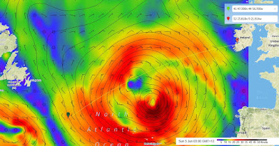
Light ENE or NE winds will continue tomorrow night, then will back toward N on Monday and increasing to 10-14 knots later in the day. Winds will continue to back through Monday night and Tuesday and will increase with NW winds at about 17-21 knots in the vicinity of 47N/32W Tuesday evening with seas running 4-6 feet. The low center will be northeast of the yacht at that time, and is it moves farther north, winds will back more to the W later Tuesday night and Wednesday with reasonable speeds.
There will indeed by a low center taking shape east of Newfoundland later next week and the circulation of the low will extend farther east by the end of the week with an occluded front moving north across the route later Friday or Friday night. This will lead to winds backing more to the south ahead of the front, then shifting to W after the front passes, but wind speeds will remain within acceptable limits, generally around 25 knots with seas at reasonable levels as well. Some rain is likely as the front approaches and passes, but nothing extreme. The yacht will likely be moving east of 20W later Friday, and will be far enough east so that the stronger winds and higher seas remain well to the west.
At this time it appears that winds will back to SW through next weekend for the approach to Ireland.
Bottom line - the outlook looks fairly good for the remainder of the crossing. No ice east of about 42W, so if the wind does become more easterly this evening or tonight, you can probably turn more north a bit if that is more comfortable or allows better sailing. In general, though, the GC route the rest of the way looks good. The low will move nicely north of the route toward the middle of next week allowing winds to become more westerly. The front later in the week will produce stronger winds, but not excessive, and the wind direction will be favorable.
Nice to see you have made enough progress that we are now talking about the approach to Ireland!
Current position (Green Mark) and weather. "2nd" low is set to track well south of boats location. Looks like they will have a few days of lighter upwind sailing before favorable winds fill in for the rest of the week.

No comments:
Post a Comment