Sorry, I've been at the pub. More soon!
Bill
Friday, June 17, 2016
Wednesday, June 15, 2016
Atlantic Crossing Map
Here is the interactive map of the Atlantic crossing:
I will be removing the map from the front page at some point, so it will live here for any future reference. Note that you can click on a marker and see the blog post that goes along with that position report.
I will be removing the map from the front page at some point, so it will live here for any future reference. Note that you can click on a marker and see the blog post that goes along with that position report.
Monday, June 13, 2016
Harbor entry is...
55 minutes away. Grey morning, we have arrived at DIngle Bay and have been escorted in by scores of leaping dolphins. Visual overload is about us, as the empty ocean seas are now replete with dolphins, birds, and mountains. More activity than has been our norm, a feast and stimulant for the eyes.
Bill
----
This e-mail was delivered via satellite phone using GMN's XGate software.
Please be kind and keep your replies short.
Bill
----
This e-mail was delivered via satellite phone using GMN's XGate software.
Please be kind and keep your replies short.
Sunday, June 12, 2016
Final Weather Update -- Thank you Ken
Hello Bill and crew -
It now appears that the low that I spoke about yesterday will track to the north of your route through tonight and that it will be a bit stronger than was anticipated yesterday. Its center will reach Galway Bay around midday tomorrow. This will mean less variability in the wind, stronger wind speeds, and wind direction generally favorable for the final 18 hours.
SSW winds will increase through the late afternoon hours, likely up to 17-21 knots toward evening, and some showers will become likely as well. A cold front trailing south from the low will pass the yacht near midnight, and wind speeds may push up to 20-24 knots in advance of the front this evening with more showers, then behind the front winds will shift to W after midnight and may increase to 23-27 knots with a few higher gusts toward daybreak tomorrow.
This means that the only engine use that you will need will be for maneuvering in the bay and harbor as you arrive tomorrow. Perhaps you’ll need to use the engine to slow down and stop as the wind whisks you into the bay rather briskly! :)
With your imminent arrival, this will be the final update for this passage. I have enjoyed participating in the voyage through the very descriptive and entertaining daily updates, and hope that my updates and advice have been useful.
As always, feel free to email with any questions.
SY Visions of Johanna Bermuda to Dingle, Ireland Crossing Day 15 - fooled you post 2 - Bonus post
DATE: Sunday, 12 June, 2016, 17:20 PM UTC
SY Visions of Johanna Bermuda to Dingle, Ireland Crossing Day 15 - fooled you post 2
North Atlantic Ocean
Position: 52 01.2N/13 03.6W
SOG 9 knots; COG 087 mag
TWS approx 16-19 kn ; TWD: approx 180 mag
Current situation: Wind has come up in the afternoon. A squall just blew by us, sailing with double reef main, staysail, and reefed jib.
All is well. 96 nm to go to Dingle Bay.
Estimated arrival remains around 0500 tomorrow morning, an hour after first light.
Best wishes,
Bill Strassberg and crew, SY Visions of Johanna
----
This e-mail was delivered via satellite phone using GMN's XGate software.
Please be kind and keep your replies short.
SY Visions of Johanna Bermuda to Dingle, Ireland Crossing Day 15
DATE: Sunday, 12 June, 2016, 12:00 PM UTC
SY Visions of Johanna Bermuda to Dingle, Ireland Crossing Day 15 - only post for today
North Atlantic Ocean
Position: 51 56.0N/14 11.8W
SOG 6.96 knots; COG 096 mag
TWS approx 9 kn ; TWD: approx 195 mag
Current situation: We sailed through the early evening hours, and engine went on at 2200 last night as the wind eased. We have been motor sailing while working out some gremlins in our autopilot, and also our wind instruments, as the ST60 wind seems to have lost all it's settings and we are getting false readings. We managed an end around fix of the autopilot, thanks to Gram's phenomenal "I got your back" support, and we are doing just fine as is, en route to Dingle. Many fishing boats about now on AIS.
This is likely the last post we will send until after landfall, estimated around 0500 tomorrow morning, an hour after first light.
All is well. 133 nm to go to Dingle Bay.
Best wishes,
Bill Strassberg and crew, SY Visions of Johanna
----
This e-mail was delivered via satellite phone using GMN's XGate software.
Please be kind and keep your replies short.
Saturday, June 11, 2016
Wx Update 11 June
Hello Bill and crew -
Read with interest the account of your trials and tribulations with the occluded front. As I said yesterday, respect for the North Atlantic is a good thing, and it sounds as though all on aboard have gained a bit more!
The time zone currently in effect in Ireland is Irish Standard Time, which is a daylight saving time zone used in the summer. It is UTC +1. I am writing this at 1125 EDT, which is 1525 UTC, and the time in Ireland is 1625 IST.
Winds through this evening will be W at about 20 knots, then will veer a bit to WNW later at night at similar speeds. Winds will then back to W again tomorrow morning and will drop off a bit.
A fast moving, but weak low will track east along about 51N tomorrow afternoon and will across 10W near midnight tomorrow night. This system will spread some rain across the yacht and southwestern Ireland later in the afternoon and through the evening. Winds will back to S later in the afternoon, and to SE in the evening, maybe even E or ENE for a time. Wind speeds, though, will be rather light through this period, 7 knots or less. After midnight tomorrow night, after a brief period of light and variable winds, winds will settle into the WNW and pick up to 9-13 knots.
Seas will continue at 4-7 feet, mainly as longer swells from the west through the weekend, perhaps subsiding a little as you approach the Irish coast later tomorrow and the winds become lighter.
Bottom line, downwind sailing through tomorrow morning, then much lighter winds tomorrow afternoon and evening with rain. You’ll likely be approaching Dingle Bay under power.
Because of the fast moving and weak nature of the low, my confidence in the wind forecast for later tomorrow and tomorrow night is below average. It is unlikely that winds will be very strong through this period, but the wind direction could end up being different than forecast.
Email with questions.
SY Visions of Johanna Bermuda to Dingle, Ireland Crossing Day 14 post #2
DATE: Saturday, 11 June, 2016, 17:00 PM Mid Atlantic time
SY Visions of Johanna Bermuda to Dingle, Ireland Crossing Day 14 post #2
North Atlantic Ocean
Position: 51 14.8N/17 36.4W
SOG 9.28 knots; COG 070 mag
TWS 10.2 kn ; TWD: 253 mag
Current situation: We motor sailed through the morning, and then engine went off 13:00 hours. There has been great sailing all afternoon, broad reaching, surfing down waves. A nice day overall. Crew is talking of timing and who will first see land or lights. We will approach Dingle Bay probably several hours after midnight early Monday morning. A small celebration will ensue I'm sure, once onshore.
All is well. 277 nm to go to Dingle Bay.
Best wishes,
Bill Strassberg and crew, SY Visions of Johanna
----
This e-mail was delivered via satellite phone using GMN's XGate software.
Please be kind and keep your replies short.
SY Visions of Johanna Bermuda to Dingle, Ireland Crossing Day 14 -Day of recuperation
DATE: Saturday 11 June, 2016, 09:30 AM Mid Atlantic time
SY Visions of Johanna Bermuda to Dingle, Ireland Crossing Day 14
North Atlantic Ocean
Position: 50 52.6N/18 36.2W
SOG 7.59 knots; COG 061 mag
TWS 14.5 kn ; TWD: 255 mag
Conditions: It's foggy and (looks and) feels just like home! Lumpy seas.
We are motorsailing nearly DDW, trying to keep AWA above 130 mag. Winds of 15-20 kn WSW to westerlies are anticipated for our approach, with maybe a shot of NW briefly nearing the Irish coast, so essentially it is a downwind approach. I need to determine whether to tack downwind with reacher (longer) or motor-sail (shorter distance at the expense of diesel) in to Dingle. Seas remain a soft topped 4-6 feet with a southerly swell interacting with a SW wind wave. Relatively, any motion is nil as viewed from the aspect of recent comps!
Current situation: Let me start around 24 hours ago. Wind picked up but slowly through the early hours of Friday morning. We had placed a third reef in the main 17:30 Thursday evening, and flew the jib for part of the night...hesitating...considering when to further shorten sail...wondering...waiting...asking...when will the frontal winds arrive? It felt a bit like waiting for Godot. Well, Godot showed up after all, at least in our rendition. The jib was rolled in around 22:30 hours Thursday night, carefully, tight and neat we felt. All this reefing explains our modest speeds through Thursday night into Friday morning, 7's early on, then 6's, as the wind remained 23 kn or less through 0500.
We also had some conflicting data weatherwise at this point. Our downloaded GRIBs indicated that increased winds and seas would arrive after daylight Friday, but with some moderation, 25 kn and occasional 30 kn winds from the south and SE. Ken McKinley's forecast was quite a bit harsher, including sustained 28-33 knot winds with some gusts possibly to 40 kn, and we would begin seeing the harshest winds after midnight Thursday and through the early hours of Friday. I always default to Ken, so we were ready!
Ultimately the front did not make it's approach known until 0630 Friday - by that time we were adding an additional 1/2 hourly log reading of wind speed, direction, and barometer reading, to our full hourly log. Wind speed jumped abruptly to 27.3 kn at 06:30 Friday, and then never looked back. So Ken's estimate of where the boat might be when the front approached was several hours off, but he nailed the intensity. Bulls eye! And I hate it when he is so right. Barometer started at the 1016 mb range at 22:00 hrs Thursday night, and hit a nadir of 1004 mb 16:00 hrs Thursday afternoon, a drop of 12 mb in 18 hours. Pretty severe, but thankfully not steep.
Wind speeds increased by the hour through Friday, literally, until maxing out to a 33.5 kn average at the 13:00 hour reading. We were sailing with triple reef mainsail and 1/2 reefed staysail at that point, seeing gusts to 39.9 knots. Overall I would not say that we were particularly comfortable on our sturdy vessel, but we all felt safe and sound. Sleep was't great, daytime meals were catch as catch can, but we all knew that this would begin to abate sometimes toward the end of the day. So we waited. Again. Waiting.
And, please don't think that we were completely hassle free through all of this, simply sitting on our thumbs. No, a vessel and crew are always tested on ocean passages (and in ocean racing for that matter) and it would be fool hardy to think that a few things would not go amiss - particularly in this ocean. You just never know when or where a mal-occurrence might pop up, especially during a frontal pass, when you are crossing the north Atlantic around 49N. So any number of eventful happenings should be anticipated, perhaps a few escapades, but hopefully no big issues. I would say we made it to the few escapades level.
Around 03:00 Friday morning the autopilot alarm went off, failure reading of "mot stall", presumed to mean motor stall. Exactly what that indicated is uncertain (mot stall is not listed in the Raymarine manual as a fault code, of course), but what it meant was jumping out of the bunk to hand steer. Denis was on watch and we initially each took a 1/2 hour turn. I was thinking about issues and possible solutions, and then simply experimented, turning the AP back on but to steer by heading, not wind. And it worked. Thank you! But I took it as a signal, a warning really, about how insignificant we were out here. Why did it happen? We had been piloting by the wind and most likely the wind shifts and building seas overloaded our AP, but I am not sure as I have no idea what the fault code might mean. And the steering was quite easy, actually. Denis commented that "she tracked well", and we found a nice soft spot to steer on our intended course, sail plan balanced (at that point staysail was still out fully), and moderate speeds in the 7 knot range. So it did not seem that AP was working too hard. Needless to say, it has not been asked to steer to wind since.
The Friday morning hours brought a bit of shuddering and bouncing of the jib stay. Tried to control with mast head bend, but no change, and shortly, we noticed that the jib was beginning to unfurl itself high up. Furling line was locked, but the top was fluttering out. We began to unroll it but it soon became apparent that the top 1/4 was wrapped against the direction of the lower furl, with an intervening hour glass. When we were unable to get it to unwrap itself by jibing, we finally found a way to have all the turns the same way, and it unfurled evenly. Whoohoo. But not so fast...this is the north Atlantic, and it was windy. Even with good attention and efforts to refurl it, the sail and then the furling drum encaptured the reacher sheet. The jib was stuck at a 50% roll...and fond memories of sailing up the south island of NZ to Picton washed over me. So at this point, an inspection was necessary, and a little jaunt up to the bow followed. This was a group effort. Denis hand steered a downwind course to mitigate seas and wind, and Andrew and Pam controlled jib sheet and furling line, respectively. Essentially, I brought the reacher sheet to the foredeck and arduously unwound it, also using the step-wise unrolling of the drum one turn at a time to assist. 30 minutes later, no worries, mate. All done, sails properly furled.
A large pod of whales joined at this point. And...
Less than an hour later, the windspeed really started to come up fast. Timing is everything.
By this time we were reaching, with speeds first in the 6's and then 5's, sailing slowly trying to keep apparent wind at or abaft the beam in building seas. They got pretty big. Definitely over 4-6 feet (really 9-12 and an occasional 16, but don't tell!). Large amounts of green water were seen strolling across our decks. We were heeling, and then heeling and rolling hard in swells. At one point a fairly loud crash was heard. The aft galley drawer slipped it's catch, and went to the ground. Fortunately, only two casualties are noted, but it still remains on the galley sole as seas are not quite yet easy enough to repair. The forward galley drawer is also questionable; latch has a fatigue crack and we have put it out of commission.
Well, I thought 3 events were a charm. Not! Around 15:00 hours, a huge amount of water washed over the deck from what must have been a particularly large swell accompanied by exquisite timing. Like being in a waterfall. Really. Neptune again made his presence known as dorades in Andrews cabin and the quarter berth (opposite sides of the boat!!) were breached, and drippings were found on the saloon table as well. By then, I realized, our trangressions. We were not at all cocky, but we were gamely surviving all the north Atlantic was throwing at us. But that's not how it's done.
Our error was, we were meaningless peons, a tiny vassel traversing a huge and unforgiving ocean, and we needed to submit. Cry uncle. Ask for kindness, and safe passage. So tail between my legs. I did. Loudly. With the greatest of respect, I acknowledged the powers of Neptune, submitted essentially on my knees, while proclaiming to all that could hear, our unworthiness in his huge sea.
And it worked. Within the hour winds began to ease, and slowly but steadily they diminished through the rest of the afternoon. Coincidence? Who knows. I am not usually a prayerful guy, but I think that this is something akin to the absence of athiests in foxholes. Either way, all is better. Good even by now!
And since I initiated this blog piece, drawer latches have been repaired.We are putting things back together, enjoying the (relatively) smooth ride.
Tactical: Get the F to Dingle.
We are looking at clocks and are having trouble figuring out whether the western most coast of Ireland is UTC-1, or UTC.
Lunch and dinner yesterday were a blur. We were on our own for lunch fixings. Dinner was make your own wraps with vegetable, bean, and turkey burgers. We even had enough greens for a cucumber/celery/onion salad with chick peas.
All is well on-board. 302 nm. to Dingle Bay approach waypoint, 10 more miles in to the harbor. Landfall is expected some time late Sunday night/early Monday. The good people of Dingle are helping us plan our approach.
Best wishes,
Bill Strassberg and crew, SY Visions of Johanna
----
This e-mail was delivered via satellite phone using GMN's XGate software.
Please be kind and keep your replies short.
Friday, June 10, 2016
WX update 10 June
Hello Bill and crew -
Glad to hear that you have come through the near gale in good shape. Respect for the North Atlantic is a good thing!
I am assuming that by the time you read this that the front will have passed, and winds will have shifted to WSW and dropped off to 20-25 knots or so. Seas will ease a little, but also become more confused with the wind shift and will likely run 6-8 feet through this evening and tonight. Winds overnight will drop back a bit more to 18-22 knots, still from the WSW.
WSW winds will continue through tomorrow, easing a bit more to 14-18 knots in the afternoon, but seas will continue in the 6-8 foot range although they will become less confused. Winds will veer to W tomorrow night, perhaps picking up a bit to 16-20 knots, then on Sunday winds will back to SW through the morning with speeds 15-19 knots before shifting to WNW and dropping off later in the day as a weak front moves quickly east.
Yet another fast moving but weak disturbance may push past the yacht early Monday on the approach to Dingle Bay with winds backing to SW ahead of it, then shifting to WNW behind it, but wind speeds remaining less than 20 knots except for a stray gust here and there.
A couple of showers are possible with the weak features on Sunday and Monday, but nothing heavy or of long duration.
Bottom line, you are in good shape the rest of the way, the worst conditions are behind you.
Email with questions.
SY Visions of Johanna Bermuda to Dingle, Ireland Crossing Day 14 post #2 - a bit of a blow
DATE: Friday, 10 June, 2016, 15:00 PM Mid Atlantic time
SY Visions of Johanna Bermuda to Dingle, Ireland Crossing Day 14 post #2
North Atlantic Ocean
Position: 50 121.0N/22 22.31W (Editor is guessing at correction here)
SOG 5.3 knots; COG 054 mag
TWS 27.6kn; TWD: 132 mag
Current situation: That's what Ari would say, a bit of a blow. Wind increased from the SE all day, and averaged 33.5 kn at the 13:00 PM log. Dangerously close to a gale. We are handling this quite well, as is Visions of Johanna. Andrew (me too) has gained great respect for the north Atlantic, and I think he is going to name his first child Pilothouse. I also think that we are over the hump as I am finally beginning to see readings down into the 20's, and even a 23 kn reading. Whoohoo.
No long epistles from yours truly today.
Still 455 nm to go to our WP approach.
Best wishes,
Bill Strassberg and crew, SY Visions of Johanna
----
This e-mail was delivered via satellite phone using GMN's XGate software.
Please be kind and keep your replies short.
SY Visions of Johanna Bermuda to Dingle, Ireland Crossing Day 14 post #2
North Atlantic Ocean
Position: 50 12
SOG 5.3 knots; COG 054 mag
TWS 27.6kn; TWD: 132 mag
Current situation: That's what Ari would say, a bit of a blow. Wind increased from the SE all day, and averaged 33.5 kn at the 13:00 PM log. Dangerously close to a gale. We are handling this quite well, as is Visions of Johanna. Andrew (me too) has gained great respect for the north Atlantic, and I think he is going to name his first child Pilothouse. I also think that we are over the hump as I am finally beginning to see readings down into the 20's, and even a 23 kn reading. Whoohoo.
No long epistles from yours truly today.
Still 455 nm to go to our WP approach.
Best wishes,
Bill Strassberg and crew, SY Visions of Johanna
----
This e-mail was delivered via satellite phone using GMN's XGate software.
Please be kind and keep your replies short.
SY Visions of Johanna Bermuda to Dingle, Ireland Crossing Day 14 post #1
DATE: Thursday, 9 June, 2016, 17:00 PM Mid Atlantic time
SY Visions of Johanna Bermuda to Dingle, Ireland Crossing Day 14 post #1
North Atlantic Ocean
Position: 49 46.2N/253 08.1W (This position doesn't seem to be correct as due north of last post)
SOG 5.0 knots; COG 067 mag
TWS 29.7 kn ; TWD: 135 mag
Current situation: Just a quick note to say all is well. Conditions overnight were mostly SSE -> south winds, 20 kn building to 24 kn. Front approached 05:00 and arrived 06:00. Wind now SE averaging 30 kn. Seas are over 4-6 feet. Bar 1009 mb. Only a few tales to tell. More later.
About 490 nm to go to our WP approach.
Best wishes,
Bill Strassberg and crew, SY Visions of Johanna
----
This e-mail was delivered via satellite phone using GMN's XGate software.
Please be kind and keep your replies short.
SY Visions of Johanna Bermuda to Dingle, Ireland Crossing Day 14 post #1
North Atlantic Ocean
Position: 49 46.2N/25
SOG 5.0 knots; COG 067 mag
TWS 29.7 kn ; TWD: 135 mag
Current situation: Just a quick note to say all is well. Conditions overnight were mostly SSE -> south winds, 20 kn building to 24 kn. Front approached 05:00 and arrived 06:00. Wind now SE averaging 30 kn. Seas are over 4-6 feet. Bar 1009 mb. Only a few tales to tell. More later.
About 490 nm to go to our WP approach.
Best wishes,
Bill Strassberg and crew, SY Visions of Johanna
----
This e-mail was delivered via satellite phone using GMN's XGate software.
Please be kind and keep your replies short.
Thursday, June 9, 2016
Wx 9 June
Hello Bill and crew -
Winds will continue to back through the late afternoon, likely running S by evening with speeds in the 16-20 knot range. Seas may actually subside a little bit through this period as the increase in seas you have seen has probably been running into old swells from the “second low” now well to your northwest.
Conditions will deteriorate fairly quickly overnight tonight as the occluded front approaches from the west. Winds will back to SSE and increase to 26-30 knots by midnight with seas building to 7-9 feet. A period of 4-6 hours of even stronger winds appears likely after midnight, probably 29-33 knots with higher gusts (maybe some over 40 knots), and seas will build to 9-12 feet during this period with locally higher seas possible. Also during this time some fairly heavy rain is likely.
Based on your current position, and assuming SOA of 8 knots, it appears that the front will pass the yacht shortly after daybreak tomorrow around 49N between 22W and 23W. Winds will shift to WSW with the frontal passage, and speeds will drop off to 23-27 knots. Seas will be confused following the frontal passage, but will generally drop off to 6-9 feet.
WSW winds will continue through the day tomorrow, easing a bit toward evening, then tomorrow night winds will back to SW as you move east of 20W with speeds in the 17-21 knot range. A secondary cold front will pass the yacht on Saturday with winds shifting to WNW by afternoon at 19-23 knots. Winds will become a bit lighter through Saturday night, then will back to SW and perhaps S Sunday morning ahead of another front approaching southwestern Ireland before shifting to W later Sunday after the front passes. Seas will remain in the 6-8 foot range from later tomorrow through the weekend along the route.
Again, the main message today is that conditions will become rather gnarly through tonight with near gale winds, and gusts above gale force along with quickly building seas. After the frontal boundary passes early tomorrow, winds will quiet down a bit, but seas may remain uncomfortable for a good portion of the day due to their confused nature.
At this point, there is little difference between a GC route and a rhumb line route. The heading at any given time can be dictated by wind and sea considerations. There is no particularly large scale tactical advantage to one route over another, although moving farther north tonight will delay the passage of the frontal boundary, and thus delay the easing of the wind. If you find yourselves being pushed farther north than you like if there is more of an easterly component to the wind than anticipated, then heaving to might be better to just wait for the front to pass. Once the front passes, winds will have a significant westerly component for the rest of the passage.
Email with questions.

Latest Grib file at Current Time showing Newfie low to the boats west with the front running N-S

24 hrs later, front has just passed boat which will have moved about 200nm to the eat. Low has turned north and will pass behind boat, leaving them moderated SW winds.
SY Visions of Johanna Bermuda to Dingle, Ireland Crossing Day 13 post #2
DATE: Thursday, 9 June, 2016, 17:00 PM Mid Atlantic time
SY Visions of Johanna Bermuda to Dingle, Ireland Crossing Day 13 post #2
North Atlantic Ocean
Position: 48 52.6 N/25 14.0W
SOG 8.41 knots; COG 080 mag
TWS 17.4 kn ; TWD: 199 mag
Current situation: After a slowish morning (6-7.5 kn), wind has clocked to the SSW and increased a bit and we have logged steady 8+ and 9 knot hours since noon. I just placed a third reef in the main, and we are sailing just forward of beam reach with jib and staysail. Speed down a touch to the high 7's.
All is well. 593 nm to go to our WP approach.
Best wishes,
Bill Strassberg and crew, SY Visions of Johanna
----
This e-mail was delivered via satellite phone using GMN's XGate software.
Please be kind and keep your replies short.
SY Visions of Johanna Bermuda to Dingle, Ireland Crossing Day 13
DATE: Thursday, 9 June, 2016, 09:30 AM Mid Atlantic time
SY Visions of Johanna Bermuda to Dingle, Ireland Crossing Day 13
North Atlantic Ocean
Position: 48 32.5 N/26 44.8W
SOG 6.59 knots; COG 086 mag
TWS 14.2 kn ; TWD: 219 mag
Conditions: Engine was on overnight until 04:30 when we jibed around to a starboard tack and sailed, broad reaching with jib. Wind continued to (sloooowly) back and eased some, and reacher went up at 06:30. Sky is mostly sunny, Bar is all the way up to 2016.5. A noticeable wave/swell set is coming onto the starboard quarter, probable first signs of the "Newfie Low".
Current situation: We continued easting as much as possible along a general GC route last night - my mantra has been...get east, young (?) man. At 1800 hours last night generator went on, but then I decided to turn on main engine for battery charging instead, and also because both our desired course and the the rhumb line were less than 30 degrees from DDW, and engine on allowed us to make best time to our Dingle Bay entry mark. Still mostly broad reaching, we are slowly heading up for speed toward a beam reach while keeping 10 - 20 degrees windward of our rhumb line - theoretically allowing the continued backing wind to bring us to the GC rhumb line...patiently...over time. Winds have been steady over the past several hours at 220 degrees mag, around either side of 16 Kn. Working hard to keep speed up near 7.5 Kn in these conditions.
Tactical: We have put enough distance between ourselves and the low to mitigate the possibilities of an unfortunate encounter of the harshest kind. In doing so, we have also delayed passage of the accompanying occluded front as described by Ken McKinley, and my read is that we will see a building wind through Thursday night, but the higher winds and frontal passage will not occur until after daybreak on Friday, with a 6ish hour interval between 05:00 and noon Friday morning as the snottiest (Yes, I can add, but please allow me some literary license for generalities). Good news is that the event will be more moderate than initially anticipated. Better news is that we have already been through (at least) this on our passage, and dealt with it for a longer time frame. Best news is that afterward, we can set our sights on Dingle.
Lunch yesterday was tuna salad with chopped celery, onion, and cumin, in wraps, with a bowl of red pepper tomato soup. Half the tuna salad was made with mayo, half with yogurt. Can you guess who ate what? Don't blame me Corinne, I'm trying! Dinner was burgers and pan fries, with cole slaw. Fresh baked chocolate chip cookies for desert. Gotta love our quartermaster, Jo!!
We moved clocks ahead again 1 hour, to Mid Atlantic time, or UTC -2.
All is well on-board. 656 nm. to Dingle Bay approach waypoint, 10 more miles to the harbor. So, there is a possibility of a late evening landfall on Sunday (light is late up here), but we will need 3 1/2 consecutive 200 nm days to achieve it. Certainly possible (to average 200 per day), but I won't count on it yet.
Best wishes,
Bill Strassberg and crew, SY Visions of Johanna
----
This e-mail was delivered via satellite phone using GMN's XGate software.
Please be kind and keep your replies short.
SY Visions of Johanna Bermuda to Dingle, Ireland Crossing Day 13
North Atlantic Ocean
Position: 48 32.5 N/26 44.8W
SOG 6.59 knots; COG 086 mag
TWS 14.2 kn ; TWD: 219 mag
Conditions: Engine was on overnight until 04:30 when we jibed around to a starboard tack and sailed, broad reaching with jib. Wind continued to (sloooowly) back and eased some, and reacher went up at 06:30. Sky is mostly sunny, Bar is all the way up to 2016.5. A noticeable wave/swell set is coming onto the starboard quarter, probable first signs of the "Newfie Low".
Current situation: We continued easting as much as possible along a general GC route last night - my mantra has been...get east, young (?) man. At 1800 hours last night generator went on, but then I decided to turn on main engine for battery charging instead, and also because both our desired course and the the rhumb line were less than 30 degrees from DDW, and engine on allowed us to make best time to our Dingle Bay entry mark. Still mostly broad reaching, we are slowly heading up for speed toward a beam reach while keeping 10 - 20 degrees windward of our rhumb line - theoretically allowing the continued backing wind to bring us to the GC rhumb line...patiently...over time. Winds have been steady over the past several hours at 220 degrees mag, around either side of 16 Kn. Working hard to keep speed up near 7.5 Kn in these conditions.
Tactical: We have put enough distance between ourselves and the low to mitigate the possibilities of an unfortunate encounter of the harshest kind. In doing so, we have also delayed passage of the accompanying occluded front as described by Ken McKinley, and my read is that we will see a building wind through Thursday night, but the higher winds and frontal passage will not occur until after daybreak on Friday, with a 6ish hour interval between 05:00 and noon Friday morning as the snottiest (Yes, I can add, but please allow me some literary license for generalities). Good news is that the event will be more moderate than initially anticipated. Better news is that we have already been through (at least) this on our passage, and dealt with it for a longer time frame. Best news is that afterward, we can set our sights on Dingle.
Lunch yesterday was tuna salad with chopped celery, onion, and cumin, in wraps, with a bowl of red pepper tomato soup. Half the tuna salad was made with mayo, half with yogurt. Can you guess who ate what? Don't blame me Corinne, I'm trying! Dinner was burgers and pan fries, with cole slaw. Fresh baked chocolate chip cookies for desert. Gotta love our quartermaster, Jo!!
We moved clocks ahead again 1 hour, to Mid Atlantic time, or UTC -2.
All is well on-board. 656 nm. to Dingle Bay approach waypoint, 10 more miles to the harbor. So, there is a possibility of a late evening landfall on Sunday (light is late up here), but we will need 3 1/2 consecutive 200 nm days to achieve it. Certainly possible (to average 200 per day), but I won't count on it yet.
Best wishes,
Bill Strassberg and crew, SY Visions of Johanna
----
This e-mail was delivered via satellite phone using GMN's XGate software.
Please be kind and keep your replies short.
Wednesday, June 8, 2016
Weather update 8 June
Hello Bill and crew -
Winds will continue backing through this evening and tonight and by tomorrow morning will be SW in the 15-19 knot range. Seas will generally remain in the 5-7 foot range through tonight, then may ease slightly during the day tomorrow as winds continue to back, likely running SSW at 14-18 knots tomorrow afternoon.
It still appears that winds will increase quickly tomorrow evening and will have backed to S and perhaps SSE by midnight with speeds up to 22-26 knots. Speeds will push up to 27-31 knots later at night, perhaps backing all the way to SE. Seas will build to 7-9 feet through tomorrow night.
The occluded front appears that it will not be quite as strong as it appeared yesterday, thus the wind speeds are not expected to be quite as high. Also, with the good speed made yesterday, it appears that the yacht will be a bit farther east than was expected yesterday, so the frontal passage will probably occur around mid morning on Friday near 22W.
Behind the front winds will shift to WSW with speeds dropping quickly to 14-18 knots, but later Friday afternoon winds will back to SW at similar speeds. Seas will be a bit confused for a while following the wind shift while subsiding only a little bit. Later Friday night winds will back to SSW and increase a bit, generally 17-21 knots by Saturday morning as a secondary cold front approaches. This front will pass sometime later Saturday with winds shifting to W behind it and dropping off to 14-18 knots. Lighter WSW winds appear likely by Sunday morning, then Sunday night and Monday mainly W winds will push back up to 20 knots or so approaching southwestern Ireland.
A general GC route still appears favorable with adjustments as needed for wind angle and comfort. It still appears that some rigorous conditions are likely tomorrow night into early Friday, but sustained wind speeds now appear that they will remain just below gale force, though some gale force gusts could occur. After the occluded front moves through, generally favorable conditions are likely for the remainder of the passage to Bantry Bay.
Email with questions.
SY Visions of Johanna Bermuda to Dingle, Ireland Crossing Day 12...and 825 nm to go
DATE: Wednesday, 8 June, 2016, 09:30 AM Greenland time
SY Visions of Johanna Bermuda to Dingle, Ireland Crossing Day 12
North Atlantic Ocean
Position: 46 43.9 N/29 54.6W
SOG 7.54 knots; COG 044mag
TWS 13.5 kn ; TWD: 284 mag
Conditions: We sailed fast through the night, good speeds as wind slowly backed to the NW. Today, winds are easing and we are working hard to keep up speed, reaching and sailing by SOG vs. AWA.
Current situation: We continue on a general GC route. We now have reacher and staysail with our perennial double reefed mainsail, working hard to keep SOG over 7.5 kn. Sea state still is lumpy abeam and not helping our efforts.
Tactical: We find ourselves turning to the north to keep up speed as wind slowly makes it's way to the west today.
Lunch yesterday was 3 bean pasta salad with accoutrement's. Dinner was a dirty rice, pan seared pork loins, and cucumber and onion salad; crew describes a foodie tour of the north Atlantic. Not as many restaurants per capita out here compared to Portland, but not bad either.
All is well on-board. 825 nm. to Dingle Bay approach waypoint. I'm not willing to make an estimate of arrival time quite yet. And don't forget to see our blog at vofj.blogspot.com for more information and expert analysis provided by Gram.
Best wishes,
Bill Strassberg and crew, SY Visions of Johanna
----
This e-mail was delivered via satellite phone using GMN's XGate software.
Please be kind and keep your replies short.
Tuesday, June 7, 2016
Weather Update 7 June
Hello Bill and crew -
Nice to hear that you have enjoyed some “hurtling" under sail…
Tropical Storm Colin has become a non tropical low along the North Carolina coast and will race northeast over the next couple of days, essentially becoming the “Newfoundland Low” as it merges with another system in that area. By Thursday morning it will be centered near 47N/48W with a strong occluded front extending southeast to about 42N/34W or so. The low will continue northeast later in the week and its occluded front will push east even more quickly, and by daybreak Friday will extend in a north-south fashion along about 23W from 50N to 45N. It will quickly push east across 20W by midday Friday, then will become a bit weaker and less well defined over the weekend while the low continues northeast well to the north.
It will be the approach and passage of the front that will provide with most rigorous sailing conditions for the remainder of the passage, but all with generally favorable wind direction.
Through this afternoon and this evening, generally NW winds in the 20-24 knot range will prevail, then winds will back to WNW later at night, and speeds will drop back to 16-20 knots tomorrow with the wind continuing to back, likely due W by later in the afternoon.
Winds will back to SW through tomorrow night, still 16-20 knots.
Seas will remain generally in the 4-6 foot range through Thursday morning, maybe a little higher at times tonight.
During Thursday as the occluded front begins to approaches from the west, winds will back to SSW and increase to 19-23 knots in the afternoon. A more dramatic increase in winds and seas is likely Thursday evening and Thursday night with wind speeds of 27-31 knots by midnight and seas of 6-8 feet. Later at night sustained gales are possible with seas perhaps building above 11 feet. Wind direction through this time will be generally S.
The front should pass around daybreak Friday with winds shifting to SW and dropping rather quickly to the 20-25 knot range with seas subsiding. After that, SW winds backing to W through the weekend approaching Ireland, wind speeds around 20 knots Saturday, closer to 25 knots Sunday, a bit less Monday.
So get prepared for a somewhat wild ride Thursday night, but otherwise some fairly good sailing conditions for the North Atlantic.
Email with questions.
SY Visions of Johanna Bermuda to Dingle, Ireland Crossing Day 11 post #2 - Making tracks all day long
DATE: Tuesday, 7 June, 2016, 17:15 PM Greenland time
SY Visions of Johanna Bermuda to Dingle, Ireland Crossing Day 11 post #2
North Atlantic Ocean
Position: 45 26.9 N/32 48.5W
SOG 8.89 knots; COG 080 mag
TWS 20.3 kn ; TWD: 0334 mag
Current situation: We have been sailing fast all day, just forward of beam reaching, and have averaged better than 9 knots (not including the twin 10 kn hours early this AM!) through the day. Yesterday was a 214 nm day...today should be similar I hope. Gobbling up those miles we are. We have full jib and staysail with double reefed main and the ride is remarkably comfortable for speed. Steady NW wind, sunny overhead, crown of clouds all over the horizon. Bar 1006.5 mb.
The pilot house protects the cockpit from the wind and there has been a bit of sunning going on today. All good.
Best wishes,
Bill Strassberg and crew, SY Visions of Johanna
----
This e-mail was delivered via satellite phone using GMN's XGate software.
Please be kind and keep your replies short.
SY Visions of Johanna Bermuda to Dingle, Ireland Crossing Day 11
DATE: Tuesday, 7 June, 2016, 09:00 AM Greenland time
SY Visions of Johanna Bermuda to Dingle, Ireland Crossing Day 11
North Atlantic Ocean
Position: 45 03.5 N/34 27.9W
SOG 8.5 knots; COG 087 mag
TWS 19.8 kn ; TWD: 354 mag
Conditions: We sailed through the night, good speeds as wind slowly backed to just west of north. At dawn, there was blue sky with scattered clouds aft and low grey clouds ahead; wind jumped for several hours to 25-30 kn, and we screamed along. In the past, Ken McKinley termed it "hurtling". Pam and I partially reefed the jib and opened the staysail, and then rolled the jib as we averaged over 10 knots for 2 consecutive hours. Sky is now 100% overcast, Bar continues to fall, now 1007 mb.
Current situation: We continue on a general GC route, still making more easterly way than NE, anticipating further backing of the wind to the NW. Low #2 is just SE of us and should cross us over the next 12 hours, winds to ease as it goes by. It heads north, and then circles back CCW to the NW toward Greenland. We now have partially reefed jib and staysail with our perennial double reefed mainsail, moving more sedately around 8.6 + knots. Sea state still is reasonably tame as winds have not pushed them up as yet. I am thinking that they will not grow much through the day, and then winds will abate to a degree later.
Tactical: We should have nice sailing over the next couple of days, backing wind, modest speeds, corresponding seas. We continue to keep a weather eye on what as been termed "the Newfoundland low", as we will be entertained by it Thursday night and Friday. Pleasantly, todays GRIBs suggest that the Newfoundland low first heads NE, but then might turn more to the north - away from us - perhaps following Low #2. In any event, if this model holds, our resultant winds will be moderated, and supportive from the SW and S as we can now contemplate our approach to Dingle Bay.
Lunch yesterday was Turkey Burgers on buns with chutney, served with slices of cucumber and apple. Dinner was a chicken stir fry a la Denis. Mealtime continues to be a fun and congenial time.
All is well on-board. 1034 nm. to Dingle Bay approach waypoint. Just starting to feel like a horse coming home to the barn.
Best wishes,
Bill Strassberg and crew, SY Visions of Johanna
PS - If I could ever convince any of the crew to make a post, you might get a break from hearing from (only) me...but sorry, no luck so far!
----
This e-mail was delivered via satellite phone using GMN's XGate software.
Please be kind and keep your replies short.
SY Visions of Johanna Bermuda to Dingle, Ireland Crossing Day 11
North Atlantic Ocean
Position: 45 03.5 N/34 27.9W
SOG 8.5 knots; COG 087 mag
TWS 19.8 kn ; TWD: 354 mag
Conditions: We sailed through the night, good speeds as wind slowly backed to just west of north. At dawn, there was blue sky with scattered clouds aft and low grey clouds ahead; wind jumped for several hours to 25-30 kn, and we screamed along. In the past, Ken McKinley termed it "hurtling". Pam and I partially reefed the jib and opened the staysail, and then rolled the jib as we averaged over 10 knots for 2 consecutive hours. Sky is now 100% overcast, Bar continues to fall, now 1007 mb.
Current situation: We continue on a general GC route, still making more easterly way than NE, anticipating further backing of the wind to the NW. Low #2 is just SE of us and should cross us over the next 12 hours, winds to ease as it goes by. It heads north, and then circles back CCW to the NW toward Greenland. We now have partially reefed jib and staysail with our perennial double reefed mainsail, moving more sedately around 8.6 + knots. Sea state still is reasonably tame as winds have not pushed them up as yet. I am thinking that they will not grow much through the day, and then winds will abate to a degree later.
Tactical: We should have nice sailing over the next couple of days, backing wind, modest speeds, corresponding seas. We continue to keep a weather eye on what as been termed "the Newfoundland low", as we will be entertained by it Thursday night and Friday. Pleasantly, todays GRIBs suggest that the Newfoundland low first heads NE, but then might turn more to the north - away from us - perhaps following Low #2. In any event, if this model holds, our resultant winds will be moderated, and supportive from the SW and S as we can now contemplate our approach to Dingle Bay.
Lunch yesterday was Turkey Burgers on buns with chutney, served with slices of cucumber and apple. Dinner was a chicken stir fry a la Denis. Mealtime continues to be a fun and congenial time.
All is well on-board. 1034 nm. to Dingle Bay approach waypoint. Just starting to feel like a horse coming home to the barn.
Best wishes,
Bill Strassberg and crew, SY Visions of Johanna
PS - If I could ever convince any of the crew to make a post, you might get a break from hearing from (only) me...but sorry, no luck so far!
----
This e-mail was delivered via satellite phone using GMN's XGate software.
Please be kind and keep your replies short.
Monday, June 6, 2016
Weather Update 7 June
Hello Bill and crew -
Glad to hear that you have pushed through the light headwinds and are able to sail again.
Winds will slowly back to N through tonight (maybe NNW by tomorrow morning) with speeds increasing to 18-22 knots, and seas will build to 4-6 feet. NNW winds are likely through the day tomorrow at similar speeds, then tomorrow night look for winds to back to NW with speeds dropping off a bit. Winds will continue backing through Wednesday and by later in the day W winds at 14-18 knots are likely. Seas will remain at about the same levels through the middle of the week.
A short term deviation of the route toward the east makes sense in order to achieve a better wind angle, then as the wind backs tomorrow night and Wednesday, you will be able to turn more toward the north. No reason at that point to go back and join the “old” GC route, but rather you can just set a new GC route toward the destination when the wind direction allows.
Later in the week we will need to deal with the “Newfoundland Low” that we have been talking about fora few days now. This low will be rather intense as it passes Cape Race Wednesday night (it likely will contain the remnants of tropical storm Colin). Later in the week the low will track east-northeast and become stronger with its circulation expanding. An occluded front in the eastern portion of the circulation of the low will move across 20W Friday night. This will lead to a period of stronger winds for the yacht.
Winds will back to SW on Thursday ahead of this feature, but wind speeds will likely remain below 20 knots. Thursday night winds will back to SSW and then to S and wind speeds will increase through the night, likely running 25-30 knots by Friday morning in the vicinity of 23W. The occluded front will sweep east across the route on Friday with S winds increasing to 30-35 knots head of it through the morning and midday hours along with seas building to 6-9 feet, then later in the day as the front passes, winds will shift to SW and drop back to 20-25 knots with seas easing a bit. Some rain is likely with the front.
Generally SW winds then appear likely through next weekend with speeds around 20 knots for the approach to Ireland. Winds may veer a bit more toward W Sunday night and Monday for the final approach.
Bottom line, generally acceptable conditions for the rest of the passage, but with a period of rigorous sailing with near gale conditions for about 18 hours later Thursday night and for most of the daytime hours on Friday.
Email with any questions.
SY Visions of Johanna Bermuda to Dingle, Ireland Crossing Day 10 post #2
DATE: Monday, 6 June, 2016, 16:45 PM Greenland time
SY Visions of Johanna Bermuda to Dingle, Ireland Crossing Day 10 post #2
North Atlantic Ocean
Position: 44 33.1 N/37 28.8W
SOG 7.29 knots; COG 098 mag
TWS 14.2 kn ; TWD: 011 mag
Current situation: We have been sailing all day, mostly close reaching either side of 60 degrees AWA. Wind has been up and down. We were screaming along with the jib in the morning, then wind eased and reacher was up for much of the afternoon, just exchanged again for the jib. Overcast, a few sprinkles, Bar 1009.5 mb.
Best wishes,
Bill Strassberg and crew, SY Visions of Johanna
----
This e-mail was delivered via satellite phone using GMN's XGate software.
Please be kind and keep your replies short.
SY Visions of Johanna Bermuda to Dingle, Ireland Crossing Day 10 - sailing, sailing...
DATE: Monday, 6 June, 2016, 09:20 AM Greenland time
SY Visions of Johanna Bermuda to Dingle, Ireland Crossing Day 10
North Atlantic Ocean
Position: 44 30.1 N/38 46.7W
SOG 8.17 knots; COG 106 mag
TWS 16.9 kn ; TWD: 027 mag
Conditions: We had a slow motor-sailing night, averaging barely 6 knots to the NE, essentially dead upwind in lightish air. We were on a slightly northerly course to position ourselves for a gradual backing to the NNE, and wind has developed, now slowly building. Engine went off at 06:50 and we have been sailing nicely, near close hauled with AWA 053 degrees.
Current situation: We continue on a general GC route - with some modest deviation. We expect wind to slowly build and back over the next 24 hours. Low #2 that will cross east of us Tuesday night has less impact per today's GRIBs.
Tactical: I have elected to follow an Optimum Course track on Expedition, deviating from the GC rhumb line initially to the east, then rejoining near 28W. By looping off the course (more east than NE) toward 45N/33W early Tuesday afternoon, and then looping back and rejoining the course toward 48:30N/28W Wednesday night, the wind stays at or just aft of the beam as low #2 passes us to the east. I'm thinking that this is doubly good - as not only might we mitigate some wind velocity by maintaining wind aft of the beam, Expedition also reads this as an optimum (fast) route - so a positive on both counts.
Lunch yesterday was really nice Quesadillas with cheddar, pico de gallo, and potatoes. Pam stole the potato idea from discussions re: pizza toppings. Well, they work nicely in Q's too. Dinner had a first course of tomato and mozzeralla caprese salad (sadly, no fresh basil), chicken sausages, and pasta with basil tomato sauce and baked mozzerella on top. Princely cashews were shared for desert with other fixings as desired.
All is well on-board. 1208 nm. to Dingle Bay approach waypoint. Over the hump, crew is happy and just beginning to think about the possibilities of arrival (KOW!).
Best wishes,
Bill Strassberg and crew, SY Visions of Johanna
----
This e-mail was delivered via satellite phone using GMN's XGate software.
Please be kind and keep your replies short.
Sunday, June 5, 2016
SY Visions of Johanna Bermuda to Dingle, Ireland Crossing Day 9 post #2
DATE: Sunday, 5 June, 2016, 10:00 AM Greenland time
SY Visions of Johanna Bermuda to Dingle, Ireland Crossing Day 9 post #2
North Atlantic Ocean
Position: 43 46.1 N/40 47.9W
SOG 6.2 knots; COG 078 mag
TWS 7.8 kn ; TWD: 019 mag
Current situation: We found some nice wind this afternoon, and sailed nicely from about 10 AM to 2:30 PM, at which point the north-westerlies died out and a lighter wind arose from the NNE. Afternoon was sunny, and with the gentle conditions, we all enjoyed hot showers in the cockpit. We are motorsailing now, seas are easing. I never knew that Greenland had it's own time!
Best wishes,
Bill Strassberg and crew, SY Visions of Johanna
----
This e-mail was delivered via satellite phone using GMN's XGate software.
Please be kind and keep your replies short.
SY Visions of Johanna Bermuda to Dingle, Ireland Crossing Day 9 - what a difference a day makes!
DATE: Sunday, 5 June, 2016, 10:00 AM Greenland time
SY Visions of Johanna Bermuda to Dingle, Ireland Crossing Day 9
North Atlantic Ocean
Position: 43 24.8 N/41 48.1W
SOG 8.6 knots; COG 070 mag
TWS 9.8 kn ; TWD: 318 mag
Conditions: Yes, what a difference a day makes! Winds have diminished from the NW overnight, averaging 6-9 knots through the overnight, and maybe adding a knot with the sun this morning. Sky is overcast, 70% cover, with the sun trying to peek through. Bar 1016, and seas average 4-6 feet, but left over lumpy and variable.
Current situation: We continue on the GC route, and turned engine on last night near 1800 hours as we needed battery charge anyway. We motorsailed with double reefed main up through the night, and I just opened the jib as we are still close reaching, nearly close hauled. We carry it well; speed increased from 7.2ish to 8.6ish knots.
Tactical: We will continue GC route and keep a weather eye first to our southeast on Tuesday, and then to our west later this week. A bit of a conundrum, as the faster we goes, the farther east and better we will likely be positioned for next Thursday location, but the closer I may get to this weakened low on Tuesday. Decisions, decisions. In any event, nothing major, and weather tracks change by the day anyway, so not really a concern. I suspect at least another 24 hours of engine time.
Leftovers made a great lunch yesterday. Dinner was meatloaf (accolades, I'm telling you mom, accolades) with hot biscuits right from the oven and salad. Delish
All is well on-board. 1353 nm. to Dingle Bay approach waypoint.
Best wishes,
Bill Strassberg and crew, SY Visions of Johanna
----
This e-mail was delivered via satellite phone using GMN's XGate software.
Please be kind and keep your replies short.
Saturday, June 4, 2016
Locus Wx June 4th
Hello Bill and crew -
Winds and seas will ease through this afternoon, and by this evening NW winds in the 13-17 knot range are likely with seas running 5-7 feet. Winds overnight tonight will veer to NNE and continue to drop off, running 8-12 knots by tomorrow morning with seas having subsided to 3-5 feet.
Winds tomorrow will veer to NE, perhaps to ENE toward evening, but speeds will generally be 9 knots or less.
Light ENE or NE winds will continue tomorrow night, then will back toward N on Monday and increasing to 10-14 knots later in the day. Winds will continue to back through Monday night and Tuesday and will increase with NW winds at about 17-21 knots in the vicinity of 47N/32W Tuesday evening with seas running 4-6 feet. The low center will be northeast of the yacht at that time, and is it moves farther north, winds will back more to the W later Tuesday night and Wednesday with reasonable speeds.
There will indeed by a low center taking shape east of Newfoundland later next week and the circulation of the low will extend farther east by the end of the week with an occluded front moving north across the route later Friday or Friday night. This will lead to winds backing more to the south ahead of the front, then shifting to W after the front passes, but wind speeds will remain within acceptable limits, generally around 25 knots with seas at reasonable levels as well. Some rain is likely as the front approaches and passes, but nothing extreme. The yacht will likely be moving east of 20W later Friday, and will be far enough east so that the stronger winds and higher seas remain well to the west.
At this time it appears that winds will back to SW through next weekend for the approach to Ireland.
Bottom line - the outlook looks fairly good for the remainder of the crossing. No ice east of about 42W, so if the wind does become more easterly this evening or tonight, you can probably turn more north a bit if that is more comfortable or allows better sailing. In general, though, the GC route the rest of the way looks good. The low will move nicely north of the route toward the middle of next week allowing winds to become more westerly. The front later in the week will produce stronger winds, but not excessive, and the wind direction will be favorable.
Nice to see you have made enough progress that we are now talking about the approach to Ireland!
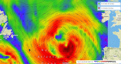

Current position (Green Mark) and weather. "2nd" low is set to track well south of boats location. Looks like they will have a few days of lighter upwind sailing before favorable winds fill in for the rest of the week.
SY Visions of Johanna Bermuda to Dingle, Ireland Crossing Day 8 - a bit of a breeze
DATE: Saturday, 4 June, 2016, 07:30 AM Atlantic
SY Visions of Johanna Bermuda to Dingle, Ireland Crossing Day 8
North Atlantic Ocean
Position: 41 47.3 N/44 56.7W
SOG 6.0 knots; COG 066 mag
TWS 21.6 kn ; TWD: 320 mag
Conditions: Winds have been steady from the NW overnight, not quite averaging 30 knots through the overnight, and slowly abating this morning as expected. Grey overcast, Bar 1021.5, and seas over 4-6 feet.
Current situation: We continue on the GC route, and slowed down as possible last night to let the low to our NE pull away from us. We placed a third reef in the mainsail late yesterday afternoon, and slowed the boat from 9 to 8 knots. We reefed the staysail in by 2/3 at 6 PM, and did average 6 knots and then gradually slower through the night as the wind eased, wind now averaging 21-22 knots on the beam. More sail will go up as wind speed slows. We will likely be motoring for a good part of Sunday.
Tactical: We will continue GC route and keep a weather eye first to our southeast on Monday, and then to our NW late next week.
Victuals continue to be a highlight. There was a lunch of squash soup and frittatas with sundried tomatoes, scallions, and feta cheese yesterday. Dinner was a Visions of Johanna offshore standard, Brunswick Stew, with a green salad. One more salad left in the larders, then on to the cabbage, celery, zucchini, and carrots.
All is well on-board.
Best wishes,
Bill Strassberg and crew, SY Visions of Johanna
----
This e-mail was delivered via satellite phone using GMN's XGate software.
Please be kind and keep your replies short.
Friday, June 3, 2016
Weather Update 3 June
Hello Bill and crew -
The trend of the earlier models has persisted with the most recent data, and this makes the outlook for remaining on the GC route through the weekend and into early next week more favorable.
As you hurtle northeast through tonight, you will be moving into an area of stronger winds and higher seas associated with the intense low now centered north of the Azores. If you reach 42N/44W by tomorrow morning (at 8+ knots, quite possible) you will be experiencing NW winds in the 25-30 knot range with seas running 9-11 feet, perhaps having reached 12 feet at times in the pre-dawn hours. If you can slow down a little this evening and tonight, you won’t see conditions quite as high.
Through the day tomorrow conditions will ease, and by evening, NW winds will be running 18-22 knots with seas having subsided to 6-9 feet. The trend will continue tomorrow night and by Sunday morning as you move east of 40W, wind speeds will be down to 12-16 knots with seas down to 5-7 feet. The wind direction will veer to NNW through tomorrow night, though.
Light NNW winds will continue Sunday with seas continuing to subside, and generally good conditions are likely early next week.
The second low will turn north-northeast to the north of the Azores Monday night and will then move generally north to the east of 30W through the middle of the week, moving north of 50N sometime Tuesday night. That will work out very nicely as you will move east of 30W on the GC route early Wednesday and will enjoy nice westerly winds to the south of the low as you move toward Ireland.
Bottom line - hang on for a bit of a rough ride later tonight and early tomorrow, then things look favorable for the rest of the weekend and for much of next week.
Preliminary Weather Update 3 June
Hello Bill and crew -
One of the overnight model runs looked much better for you regrading the second low with a track south of 40N and a weaker system through the weekend, then a turn to the north-northeast east of 30W early next week. This is only one model run, and I want to see the next run to see if this is consistent or not.
If it is, then you may not need to deviate from the GC route later in the weekend, and might be able to continue toward Ireland on that route.
In the short term, staying on the GC route is best, even with the headwinds and difficult seas. If this second low does end up following a track as was anticipated yesterday, then you need to be in a position to move farther north.
Winds today will back slowly toward NNW or perhaps NW, but speeds will increase a bit as you move closer to the circulation of the first low. You will also move into a region with larger seas, probably peaking in the 9-11 foot range later tonight and early tomorrow with wind speeds in the 20-25 knot range at that time. Conditions will then ease tomorrow afternoon and tomorrow night.
With the possibility of the second low being farther away from your route, you probably don’t have to push the SOA quite so much today, in fact being a bit slower will mean slightly less wind and sea for you later tonight.
I’ll send a more complete report later today, just wanted to get you this update.
Email with any questions.
…
P.S. In case you were wondering, then genesis of what I have been calling the second low was partly a fairly weak disturbance which yesterday was in northwestern Canada. As that disturbance moves farther east and is able to be better resolved by the models, the forecasts will become more reliable. All in all, though, what the numerical models can do as far as predicting weak disturbances in the flow to evolve into significant systems with reasonable accuracy is remarkable. But it is not 100 percent, for obvious reasons. So we will keep watching….
-- Editors note: Bill & Ken had several back and forth e-mails yesterday (offline) sorting out the best tactical option to deal with this 2nd low that is forecast to travel across the previous southern route option middle of the week. As forecasts for this system were still very early and the system is not yet developed there is a bit more uncertainty about just how strong it will form. The several models I was looking at yesterday all agreed on timing and location, but strength of the low varied considerably. Of the 4 models I have been able to look at today, 3 (GFS, PWC, & CMG) show a weaker system than yesterday's forecast with only the PWG model still showing it forming quite strongly. In any case, all 4 show it tracking basically through the 39N/39W waypoint that Bill had been considering going through before yesterday, so this is why the boat has reverted to the original waypoints that Ken had suggested a week ago. Basically they have turned towards Ireland which means some upwind sailing, but at least on a relatively direct route for now.

This screen capture shows the boats position as of this afternoon (green marker) with the weather forecast for Monday night. By then the boat should be in the middle of the blue light air section with the 1st low well off to the east and the 2nd low due south of the boats expected position.
SY Visions of Johanna Bermuda to Dingle, Ireland Crossing Day 7 post #2
DATE: Friday, 3 June, 2016, 16:30 PM Atlantic
SY Visions of Johanna Bermuda to Dingle, Ireland Crossing Day 7 post #2
North Atlantic Ocean
Position: 40 54.3 N/46 28.7W
SOG 8.0 knots; COG 068 mag
TWS 23.9 kn ; TWD: 341 mag
Current situation: Wind started backing to the NNW at 1300 hours, and engine went off. Wind has continued to back and build, now 21-25 kn, G 20. We are now moving with a vengeance, double reefed main and staysail, close reaching 63 degrees AWA, mostly averaging over 8 knots. We are making tracks to the north as planned.
We should pass this evenings WP around 19:30 this evening, and expect these winds to hold through the night. If any more wind is forecast, then we will need a third reef. Conditions should begin to ease tomorrow.
All is well on-board.
Best wishes,
Bill Strassberg and crew, SY Visions of Johanna
----
This e-mail was delivered via satellite phone using GMN's XGate software.
Please be kind and keep your replies short.
SY Visions of Johanna Bermuda to Dingle, Ireland Crossing Day 7 post #1
DATE: Friday, 3 June, 2016, 09:30 AM Atlantic
SY Visions of Johanna Bermuda to Dingle, Ireland Crossing Day 7
North Atlantic Ocean
Position: 40 22.8 N/47 25.5W
SOG 6.3 knots; COG 067 mag
TWS 16.7 kn, ; TWD: 015 mag
Conditions: We are purposefully moving north, motor-sailing with double reef main and staysail. AWA 30 degrees.Seas are over 4-6 feet. Mostly sunny, and Bar is 2029 mb. It is brisk outside.
Current situation: We are on a northeasterly course right now accepting less than ideal upwind motor-sailing to make distance to the north. Yesterday's tactical decision, and after consulting with Ken McKinley, was to put up with some discomfort now in order to be well north of 40N by Monday as a low will cross down there. I anticipate a shift to wind west of north sometime today, and NW (hopefully) tonight. A NW wind will enable us to shut down engine and sail.
Tactical: While I contemplated catching an eddy for a ride north, I think that there could be some significant wind vs. current effect there, so we will stick with KM's provisional waypoints. We will plan to make as much westing as wind conditions allow, continuing this general course through Tuesday. Then it will be our time to head for Dingle Bay, our port of call.
And...Drumroll, please! Lunch yesterday was a melange of left overs and tuna and egg salad sandwiches. Very tasty and satisfying. Trudy's chicken Parmesan was an absolute raving success for dinner, served with peas and her home made marinara sauce over pasta. It is hard to explain what a savory and comforting meal feels like out here. Well, the crew can and it is appreciated.
Rule #1 was again breached this morning. This time Denis and I took the drain apart and replaced it with gobs of silicon. Cautiously optimistic.
All is well on-board. Conditions will ease in 24 hours or so. Spirits are high. And happy birthday Tavis Moonan.
Best wishes,
Bill Strassberg and crew, SY Visions of Johanna
----
This e-mail was delivered via satellite phone using GMN's XGate software.
Please be kind and keep your replies short.
Thursday, June 2, 2016
Updated Ice Chart as boat heads North


Weather discussion from Ken today suggested they start great circle route from this evening, getting north sooner rather than later to avoid the worst of a low pressure system forming off the mid atlantic states as we speak that should cross behind them sometime middle of next week.
-- Gram
SY Visions of Johanna Bermuda to Dingle, Ireland Crossing Day 6 post #2 - day of little change
DATE:Thursday, 2 June, 2016, 16:30 PM Atlantic
SY Visions of Johanna Bermuda to Dingle, Ireland Crossing Day 6 post #2
North Atlantic Ocean
Position: 39 22.7N/49 23.0W
SOG 8.25 knots; COG 10 mag
TWS 19.2 kn; TWD: 017 mag
Little has changed except our position!.
All is well on-board.
Best wishes,
Bill Strassberg and crew, SY Visions of Johanna
----
This e-mail was delivered via satellite phone using GMN's XGate software.
Please be kind and keep your replies short.
SY Visions of Johanna Bermuda to Dingle, Ireland Crossing Day 6 - hey baby it's cool out there
DATE: Thursday, 2 June, 2016, 10:30 AM Atlantic
SY Visions of Johanna Bermuda to Dingle, Ireland Crossing Day 6
North Atlantic Ocean
Position: 39 18.9 N/50 23.5W
SOG 8.9 knots; COG 096 mag
TWS 21.1 kn; TWD: 017 mag
Conditions: We are close reaching, AWA 65 degrees. Wind has been northerly since midnight, and over 20 kn for the past 5 hours, with a few higher gusts. We put a partial reef in the jib and opened the staysail at 0430 this morning as we are not racing and we are more comfortable at 7.5-9 knots vs. 9-10 knots. Seas are over 4-6 feet. Mostly cloudy, sun trying to peak through, and Bar is 2026 mb.
Current situation: We are on an easterly course right now. Any change to a northerly course will depend on tactical decisions and an anticipated backing of the wind to NW in 24 hours or so. Sea state is a little close and steep, but not too bad, especially with our current sail configuration. Water temp changed from 73.4 degrees to 62.6 degrees at midnight, indicating that we were out of the Gulf Stream; people are tending toward long sleeves and long pants.
Tactical: Question now will be whether to continue east for a few days or whether to turn to the north GC route as able. This is when we really appreciate Ken McKinley's expertise.
And, in case anyone is concerned that the North Atlantic will crimp our culinary style, we are (still) doing just fine, thank you. Lunch yesterday was hummous roll-ups with cucumber - and Trudy's home made hummous was again complimented by all. Dinner time was (again) a bit bouncy (hold on to your plates), but the black bean burgers, fries, pickles, and green salad were not too hard to handle.
It's a big ocean out here...seemingly bigger by the day.
All is well on-board.
Best wishes,
Bill Strassberg and crew, SY Visions of Johanna
Please delete this email message if you reply, or start a new message. Thank you
----
This e-mail was delivered via satellite phone using GMN's XGate software.
Please be kind and keep your replies short.
Subscribe to:
Posts (Atom)