Tuesday, April 3, 2012

Akaroa and Banks Peninsula


South Island New Zealand

Lots of catching up to do! We departed Dunedin for the Banks Peninsula where we anchored outside the vacation/holiday type area of Akaroa. Johanna and Gram think it may be the prettiest place we have been - I agree it was very pretty, but in a more tame way - and different compared to areas we have ventured, such as the Fiords and Stewart Island.


Weather conditions improved. The large scale weather patterns changed, but now on the South Island east coast, we were not exposed to the westerly winds of the roaring forties. We also made distance to the north, up to 43 south, from our low of 47 south around Stewart Island.

Akaroa had some great hikes and walks to choose from – including a 12 mile long and rugged loop up to a 2760 ft. peak which overlooked the peninsula. The views were great, and it was even hot. Johanna was delighted and reported that she wore shorts for the first time in months.


While in Akaroa, we also had a few nice lunches out, enjoyed walking in the “trendy” town, and visited the local artisan and jewelry shops...


but after several days in Akaroa Harbor, a good weather window presented itself, and we headed out to 'round the peninsula, on the way to Lyttleton. En route, we stopped for an overnight in Flea Bay. Very pretty, with more good walking and hiking.


Next stop - Lyttleton

Sunday, March 11, 2012

6 Nights in Dunedin

South Island

New Zealand

5 miles South of Akaroa and the Banks Peninsula


Dunedin, a beautiful city of Victorian architecture, is a Scottish settlement of 140 years ago. Located at the base of the Otago peninsula, it has a long sinuous harbor, but unfortunately one without satisfactory anchorages. The harbor is geared to the commercial needs of Port Chalmers, just outside Dunedin, and movement is "allowed" by harbor control. It does not seem that they have a feel for the needs of boats our size; their initial suggestion was for us to tie to a (very) small pontoon at the base of the harbor while we figured out a plan. Conditions did not allow and we ended requesting permission to anchor temporarily just outside the traffic lane. We then considered entering the Otago Yacht Club Harbor, but the narrow shallow entry and small space made this unthinkable in 30 knots of SW wind – we would have had to dash through a 45 foot wide pass with a cross wind, buck a 1.5 knot cross-current, and could enter only just before high tide, rafted to another boat, and then would have settled gently on bottom at low. We took a pass on that one.


 Choices were scant and ultimately we headed back towards Port Chalmers where we anchored in a mildly protected spot between Back Bay Beach and Goat Island. We were still very exposed to NE winds, and swung fully with the tide. It was okay, but not great and we endured 6 nights in this area, with the wind turning 180 degrees every day or so, and only 2 nights with less than 20 – 30 knots.


Once finally settled, we looked up Colin and Chris, Kiwis and good friends of (Hal and Elizabeth) our friends back in USA .  Colin and Chris invited us for "tea" (dinner) our first evening, and they visited the boat the following day. They also offered us a set of wheels, which really enhanced our stay. The car made our "out of town" anchorage much more livable, and we used it for shopping, for supplies, and for touring. We visited art museums and gardens downtown, and spent one fantastic sunny day biking around (and up) the peninsula when we visited the Larnoch Castle. We had dinner with another friend and Dunedinite "Kate the Great", and spent another evening right on the "pitch" in first row seats watching Otago's pro rugby team, the Highlanders, best Australia. We also refilled diesel tanks at the commercial wharf, filled our propane tanks, and food shopped. The Saturday farmers market was great.


We squeezed in "a wee bit" of boat work as well and left yesterday mid-day for Akoroa and the Banks Peninsula, near Christchurch. Our anchor and chain cleansed the harbor bottom of one huge tree trunk and an old mooring wire as we departed, and we also spent 25 minutes scrubbing our keel bottom in the nearby silt after extricating ourselves from the former. Departure planning has been a study in Kiwi weather and forecasting. Winds were initially to be variable to 15 knots SW, from far astern, while increasing to 25 knots after arrival the next day (today). Gribs were even lighter. A "complex front" was described by NZ Metservice, which I have learned is weather-speak here for a difficult to forecast front with conditions that are bound to change – don't really trust the forecast. After we left, the forecast changed to 25 knots, and we saw 25 to 30 knots with 35 to 38 knot gusts all night, fortunately on our stern or quarters. It is easing now, but is forecast to be South 15 knots tending to NE 15 knots in the afternoon, changing to 25 knots SW in the evening. It is forecast to change back to NE 15 knots tomorrow night, then tend to NW 15 knots in two days, and south 15 followed by NE 15 in 3 days. Crazy! But I don't really believe it.


We are now 6 miles outside Akaroa. All is well.                                                                                                                                                                                                                                                                                                                                                                                                                                                                                                                  


--
WMS

Thursday, March 8, 2012

Biking in Dunedin

A fabulous warm(ish) sunny day to tour the Otago peninsula. We had a hard climb up to the only castle in New Zealand then a nice ride down to portobello and then a nice 10 mile ride back to the car. An amazing day with fabulous views.

Sunday, March 4, 2012

Univ of Otago

Duneden NZ

Arrived this morning at first light. Spent the morning going up and back down the harbour finding a place to anchor and now getting a little tour with our new best friends, Colin who we met through Bills old partner Hal.

Beautiful university and quite a bit warmer here

Saturday, March 3, 2012

Departing Stewart Island

Hello again, from Stewart Island, and sorry for the scarcity of posts. We have been out of routine after sailing from Port Pegasus to Port Adventure and on to Patterson Inlet...we have been in and around Patterson Inlet and the town of Oban for the past week or so.  Bruce and Alene were able to stay with us for a few days early on, but then had to start back to rejoin Migration. Visions of Johanna was spiffy and waited patiently for our arriving Stewart Island guests -  (long-time friend) Nancy and Gregg from southern California, and Carmel, who  joined us for her holiday as well. The past week has been spent socializing, tramping, and foraging. We were already loaded with treats, and then added various specialties such as fresh blue cod, scallops, and mussels to an already pumped up menu. It was a cruise for gourmands, for sure. Weather though resorted to Stewart Island's well known rain followed by cold cloudy weather, occasionally interspersed with sun…but that did not dampen spirits and the nice days were simply fantastic.

G&N left 2 days ago, and we are again rejoining a cruising routine. We had to say so long to Carmeland have a reasonable weather window to head north towards Dunedin today. We will keep in touch.


Bill


--
WMS

Thursday, February 16, 2012

Hello from 47 south

Thursday 1900 hours
Easy Harbour
Stewart Island
47 09S
167 34 E

We had an easy and uneventful motor sail today, passing south across the entry to Foveau Straight and the Solander Islands down to the west coast of Stewart Island. Easy Harbour indeed is a well protected spot - perhaps the only protected anchorage (except I would think in a SW gale) on the west coast of Stewart.

We celebrated with appetizers of fresh baked bread in the sunny and warm cockpit as we enjoyed the spectacular scenery including green hills, smoothened rocky peaks, and many islands.

Tomorrow we will head with a moderate NW breeze and a following the tide around the SW Cape - to Port Pegasus on the SE coast.

All is well.


----
This e-mail was delivered via satellite phone using GMN's XGate software.
Please be kind and keep your replies short.

Wednesday, February 15, 2012

Wednesday 8PM
Preservation Inlet
Kisbee Bay

We have had 2 great days in "Prezzie" as they say locally, and hoped for one more before moving on to Stewart Island. We have been watching our weather window and days ago, Johanna said "I don't know about Friday...it doesn't feel right" as we discussed Thursday vs. Friday options. As usual, her instincts were right on and it is best to depart tomorrow.

Clearly, one secret to a happy life is to have a Johanna watching over you...and lucky me... I've got two!

Winds should be light and weather should be fine for crossing the entrance to the Foveaux Straight. We tentatively plan to head to "Easy Harbour" on the west coast, unless tides and timing allow passage around the Southwest Cape to Port Pegasus. This will be our first foray into the Southern Ocean.

Everyone is well, and all is fine. Next update will be from Stewart Island late tomorrow.

Bill

----
This e-mail was delivered via satellite phone using GMN's XGate software.
Please be kind and keep your replies short.

Wednesday, February 8, 2012

Dusky Sound

We sailed yesterday from Beach Harbour in Breaksea Sound to Dusky Sound, and are tucked into historic Luncheon Cove. Dusky is the largest of all the Sounds, and is reported by Billy Williams from Deep Cove Hostel to have as many islands as there are days in the year – but we have heard more than a few Kiwi tales, and are not yet convinced. Captain Cook sailed by here in 1770 and returned to explore in 1773, when he made 5 weeks of astronomical observations across the sound at Astronomer Point. Cook dined on Crayfish in this cove, and went on to explore and name many parts of the sound He named many features and discovered a "New Passage", later named Acheron Passage, that connects Dusky to Breaksea.

Yesterday we met Toby and Kath on the Kiwi sailing yacht "Solstice" visiting Fiordland from Keri Keri, returning for the second year in a row. They bypassed Milford/Doubtful areas this year and sailed directly to Dusky, explaining that this, Chalky, and Preservation were their favorites last trip, and they wanted to maximize their time here. They were kind enough to share local knowledge and led us through the narrow passage into the cove. This part of Dusky reminds me of many areas in Penobscot Bay or the Boothbay region and the gut – many islands with slim passes between and enough intervening rocks and obstructions to keep you honest.

Toby and Kath showed us a spot to dive for Crays, and gave us three large ones, stating that they were "sick of them" at this point. They also showed us where to hunt for Paua (Bruce found two that we enjoyed for appetizers last night), and there was a tiny cove nearby with a seal colony and loads of frolicking pups. This part of Dusky is a popular area for commercial fishing boats to work from. The vessel "Loyal" arrived from Bluff yesterday to tie alongside its permanently moored barge, complete with a supply hut, secondary storage barge, and satellite TV. I am not kidding. That was the second satellite TV antenna we spotted. The first was even more peculiar as it sat shore-side next to a simple large vertical granite face which the boat side ties to.

Today is the first rainy day in several, and we are well "spider tied" in this small cove; wind is due to shift from North to South today as this weak front passes. Hopefully rain will end by afternoon. Everyone has enjoyed the cove so far as it seems to be a "sand fly free zone", and there is much to see and do. We will likely "share a beer" with the crew of Loyal late this afternoon.
All is well.


----
This e-mail was delivered via satellite phone using GMN's XGate software.
Please be kind and keep your replies short.

Friday, February 3, 2012

A Four Sound Day

We left Alice Falls Anchorage in Thompson Sound Wednesday with plans to move to Anchorage Cove, and stage ourselves for departure the next day to George Sound. We found Anchorage Cove to be small and poorly protected from southerlies. There is a strong river current and visible rip with wind against current. We left after dropping anchor twice, unable to lie in a safe position allowing a stern line to the island.

Cruisers info: There is a bouyed line from shore to island, but it is not big enough to accommodate a boat our size, and it is relatively shallow - about 8 feet at low. The fair weather anchorage depicted in the guide is now too deep, and there is not enough room to drop a hook with a line ashore by the all weather site in anything but benign conditions.

We turned and went back into the sound to Southwest Arm, where we found satisfactory anchorage and spent a nice night. Forecast was for diminishing winds. They did.

Cruisers info: The bar at Southwest Arm provides only fair holding, and is made of softball to volleyball size stones. There is a good line strung shore to shore at the base of the cove, and we used it for two abreast quarter lines, which minimized swing as well as ability to drift inshore. I would not consider this all weather compared to Alice Falls.

We had a mostly motor sail to George Sound on Thursday, anchoring in Deas Cove. George Sound was different, still tall cliffed but less steep, and had sharply sloping but green covered walls, instead of the sheer cliffs in Milton Sound. We had a nice tramp over to Neck Cove on the other side where we crossed a relatively recent slide. The area looked like the aftermath of a New England ice storm - there was a small forest of leafless and broken trees as we walked over a scrabble of rocks. We found trail blazes less then knee high, and we estimated about 4' of slide below us. Definitely not a good area to buy real estate.

We saw our first boats in over a week, and heard chatter on the radio. Thompson Sound is one of the Sounds that connects to others inside - and we were seeing tour boats go up the sound from their base in famous Doubtful Sound, our next planned stop. By this time, we were also in nightly contact with Mare` of Bluff Fisherman's Radio. She is on 4417 USB 2030 NZT, and is happy to connect with cruisers along with the network of fisherman that check in regularly.

Cruisers info: The orange bouy at the head of Deas Cove brings a large hawser line from shore. We moored bow to this with a dock line and brought a stern line to the west shore. Trees are diminutive, but there is one 4' round waters edge boulder that happily accepted a surrounding chain, which we then led to our stern line.

Friday was a 4 sound day - as planned we left Deas Cove in light winds in Thompson Sound, and cruised by the entry to Bradshaw Sound as we entered Doubtfull. As it is reachable by cruise ship or adventure touring, Doubtful is known as the get-away sound. There is a small number of inhabitants - fisherman have set up a "hotel" to raft their boats to, and there is a hostel at Deep Cove, a base for a few intrepid tourists. We chose to spend our first night in Crooked Arm which we found to be a stunning, long, sinuous sound. There were hugely tall mounded peaks layered upon one another - breathtaking. If we ever get internet again, we will send pictures! There is also a true swing anchorage at the head of the sound - our first easy anchoring in weeks. The walk across to Dagg Sound (our fourth sound of the day) was rugged - very rugged. 4 Km in 2 hours R/T. Beautiful and enchanting bush ensconced in some tough terrain.

Today is a bit wet, but nothing terrible. We will likely head over to check out Deep Cove.

All is well.

Bill


----
This e-mail was delivered via satellite phone using GMN's XGate software.
Please be kind and keep your replies short.

Sunday, January 29, 2012

Milford and George Sound

Hello from George Sound in Fiordland. We departed Milford yesterday after a short but memorable visit.

Our entry to Milford was an auspicious one as we ducked into the sound just before a front crossed from south to north. Fronts in the higher latitudes of the South Pacific typically come from the NW with rain, and turn to the SW, with clearing. It blows from the west for a time as it backs to the SW, and this is where our entry became interesting.

For sailors who come behind us, it should be noted that there is a constriction in the fiord 1/4 of the way into the sound, at Dale Point, where the fiord takes a dog-leg left from north to east. The glacial cliffs also rise abruptly at this point - and we were just through this westerly constriction as the front passed. While we expected some protection from the strong north-westerlies we experienced outside, Turgen, a local tourboat skipper, told us that the narrow middle portion will accelerate strong westerlies as a front passes, and we were both in the zone as that occurred; he was captaining a large 200 passenger sightseeing vessel. I will refrain from "fish tales", but suffice it to say that there were powerful gusts and rain that obscured the cliffs to port and starboard. Turgen was forced to make an unscheduled stop at a mid sound mooring in Harrison Cove as windshield wipers blew off his windows, and passengers were panicking. His maximum gust recorded was 93 knots.

We were fortunate to have a strong crew and an even stronger boat - we fared well. We have truly enjoyed Bruce and Alene's presence aboard, but never more as the five of us kept our course, navigated, and communicated with fisherman and port control to gain some local knowledge. We were told that the Deepwater Basin remained still and calm, and Kim, a skipper of one of the small passenger ferries, offered to lead us through the pass into the basin. By the time we entered, it too was rather frothy. Kim led us to a mooring in the very south east corner of the basin - by the Pilot boat, but the strong gusts made pick up difficult. We then tried the "anchorage" in the south west corner. This was tricky as it was hard to nail the right spot to drop, allowing proper depth and location. We tried once and let 390' of chain down. We finally went back, waited for the right moment, and picked up the large and safe mooring. Bliss. We were swinging only a boat length from shore, and confirmed 60' depth with our hand held sounder.

As for communication, tour boats and port control monitor VHF ch 14, and fisherman typically use ch 66 and (primarily) 67. Our third contact was Ash (and partner Katy) at the Fiordland Lobster Company. Ash facilitated communication with Kim and monitors ch 62. Wharfage (rough) is available, as is diesel.

Once comfortably moored, we marveled at the scenery. We were literally surrounded by waterfalls, and counted over 200 sightings on the way in. Rimmed by 1600 meter sheer granite cliffs, magical and misty are the sounds in the rain. Fortuitously, the following day was dry and sunny, and after making the boat shipshape, we explored "downtown" Milford Sound, and walked to the massive Bowens Falls. Rain returned the next day. We accomplished many indoor projects, and went ashore to thank Ash and Katy. They reciprocated in kind with tasty gifts, a Fiordland book, and a dozen frozen barracuda heads to use as crayfish bait. We were later joined by Bruce and Alene's friend Kirsty who works at Mitre Peak Lodge. Kirsty comes from a family of cruisers, and arrived with gifts of fresh fruit and breads. Clearly experienced!

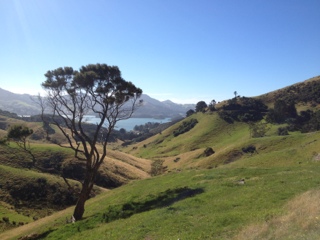
Although another day or two in Milford would have been ideal ((to do more exploring and tramp the end of the famed Milford Track) , weather windows dictated yesterdays departure. We had a 25 nautical mile upwind motor (mainsail up for roll control) and had a calm entry into George Sound. The fiords are all different. Milford was remarkable for it's sheer granite cliffs and incredible falls. George is not quite as steep, but is more forested (bush in Kiwi speak). Equally beautiful, although perhaps not quite as dramatic.

Today should be pleasant, but another front is coming tonight and we have chosen to lie in the Alice Falls Anchorage at the end of the south east arm. We are situated in a 1/4 mile basin with 300 degrees protection. There are shore tie-ups available, and we have a 6 point tie including bow anchor, 2 bow breast lines, two stern quarter lines, and a stern line. This anchorage has bouys astern to bring ships lines to, and polypro shore lines hung on trees for bow lines. We dropped the dinghy and B&A first checked out the situation and then ran lines ashore. Stern line goes aft to a set of triple of bouys, and quarter lines tie to rings midway down the lines as they go ashore. We chose to tie our port stern line directly to a tree on the bank, and brought our own port bowline to shore as well, as the shore line looked worn.

We are well set up in our hurricane hole for potential 40 knot winds tomorrow. Mean while, Alice Falls descends directly into our basin, there is not a ship for 25 miles, and we have our crayfish pot out while B&A scavenge for mussels and fish for blue cod. We will hike (tramp) the falls later.

All is well.

Bill

----
This e-mail was delivered via satellite phone using GMN's XGate software.
Please be kind and keep your replies short.

Wednesday, January 25, 2012

Likely last cell reception

Off fox glacier

Our last evening falls and we are also seeing the likely end of cell reception for a month. We will stll be posting my say phone but unlikely to add any pictures till we get back to civilization. Seas are staring to build from the southern ocean low which has slowed us a bit. Hopefully the wind will clock to the west soon and we can make some miles under sail as opposed to the upwind motoring we have been dooming for 2 days.

Tuesday, January 24, 2012

Heading south along the west side of South Island day 2

42 22 54S/170 47 70 E
South Pacific Ocean
Off Greymouth, NZ
Winds 10 - 13 knots SW
Course 189 Mag
Speed 7.7 knots

There is no shelter along this rugged coast, and once you pass Farewell Cape, the passage is 320 miles to Milford Sound. We left Tasman Bay with a reasonable weather window, but also with the knowledge that we wanted to be in the sound by Thursday evening, 60 hours after departure (late Wednesday nite for you east coasters) , as a low would pass from the south. After a pleasant motor up Tasman Bay, our encounter with Farewell Spit and Cape was again quite memorable for winds and waves in excess of the forecast. Lumpy 4-6 foot and close spaced square waves provided over 24 hours of rock and roll until we got far away enough from the South Island's north face to leave land effects behind. Crew remained happy and quite comfortable though, as Bruce, Aline and rest of the crew enjoyed the wonders of the pilot house. Johanna was prepared, and had made dinner earlier in the day - so we were able to feast on a baked pasta dinner with white cheese sauce and smoked chicken - devoured in deep offshore bowls of course.

Today has seen the wind and seas settle. Wind is still by the bow, so do we continue to motor sail in order to make good time and keep on schedule. Winds will clock around to the west and NW late tonite, and we should have speedy sailing and a timely arrival in 24 - 26 hours or so. We will send next update tomorrow morning.

Bill

----
This e-mail was delivered via satellite phone using GMN's XGate software.
Please be kind and keep your replies short.

A bit Grey

18 miles off. Greymouth

A bit grey but getting a nice lift off Greymouth as we hug the coast on our way south. More from Bill soon.

Wind finally as forecast

41 15.0 s 171 25.3 e

We have finally gotten away from the significantly higher than forecast wind we saw around farewell spit. Effectively back on schedule and motoring into 8 to 10 knots as planned. Not ideal conditions but not too bad by any means.

Monday, January 23, 2012

Fish on

Farewell spit

Just caught a beautiful albacore tuna. Grilled tuna for lunch. Yum!

Our supercrew

Joining us and spoiling us completely are Bruce and Alene from Migration (http:\\Brucebalan.com/migrations).

Bound for Fjordland

We have just left Abel Tasman bound for Milford Sound. Weather this morning is beautiful once again. A few more clouds in the sky today but still crisp a bit cool and very sunny. Weather looks reasonably good for the trip though we will have to motor most of the way there. Hopefully the winds will stay as light as forecast and it will be an easy trip. Should be in Thursday evening. We do now have satellite Internet so we will be posting updates as we go.

Thursday, January 19, 2012

A crazy last few hours

Abel Tasman. South island. New Zealand

Bill and I were having a fabulous afternoon hand steering the boat in 20 to 25 doing 10 to 12 knots and loving it. All was well and good till we got to to farewell spit and suddenly had 40 knots. The boat rounded up and the rudder stalled and there wasn't anything I could do about it so we started the engine and quickly reduced sail from full main, jib, and staysail to quad reefer main and just the staysail. It want pretty but all was ok. We then sailed across golden bay under these handkerchiefs still doing 10 knots in 35 knots of wind.

Got into the anchorage just as the last of the light was fading at about 9:30 and had 25 knots till we really tucked in behind a big cliff. Good news is we are safe and comfortable with just 5 knots of breeze in the anchorage. Staying up to help out friends Paikea Mist come into the anchorage in the dark as they were a few hours behind us.

Tomorrow we pick up Bruce and Ailene from migrations who will be joining us for a few weeks as we head to Milford and doubtful sounds.

Coming into Abel Tasman

15 miles north of Farewell Spit

Great passage. Mostly quite calm though this afternoon it has been a spirited ride downwind in 25-30 knots with some higher gusts. Hit 12.4 knots at one point. Hand steering as the autopilots are having trouble with how much sail area we have up but we are trying to get anchored before it gets dark.

First night out

35 38.9s 172 19.4e
03:00 18 January 2012

First night offshore in quite a while and all is well. We got around cape Rienga with favorable current though that did mean wind against tide and some fairly steep seas. Current is now a bit on the nose though not too strong and of course our destination is dead upwind. We are motor sailing in the light head breezes hoping the wind backs as forecast and we can start sailing for real soon. Pikea mist has been about 7 miles off our stbd bow for hours now so it is nice to have some company out here.

Monday, January 16, 2012

En route to Abel Tasman

Cape Rienga, New Zealand

Just departed north end of the north island bound for golden bay in the Abel Tasman area which is in the north east corner of the south island. We will be without Internet till we arrive but will post when safe and sound. We do have 2 other boats within short range we are talking to by radio heading the same way. Weather window looks quite good and the boat is fully stocked and ready for the trip. Once there we will get our sat phone working before we head into the civilization abyss of Fjordland. Should arrive late Thursday local time.